|
OpenRoads Designer Software
263196 INR/Piece
Product Details:
- Capacity (Person) Multiple Users (Network License Supported)
- Language Support English
- Support System Comprehensive Online Help, Technical Support
- Security Features License Protection, User Authentication
- Usage Design, Modeling, Simulation, Analysis
- Compatible System Windows 10, Windows 11 (64-bit)
- Interface Type Graphical User Interface (GUI), Ribbon Interface
- Click to View more
X
OpenRoads Designer Software Price And Quantity
- 1 Piece
- 263196 INR/Piece
OpenRoads Designer Software Product Specifications
- Design, Modeling, Simulation, Analysis
- Windows 10, Windows 11 (64-bit)
- Graphical User Interface (GUI), Ribbon Interface
- Multiple Users (Network License Supported)
- English
- Design Software
- Comprehensive Online Help, Technical Support
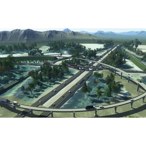
- Civil Infrastructure Design, Road and Highway Engineering
- License Protection, User Authentication
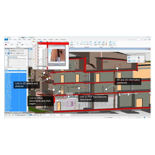
- 3D Modeling, Corridor Modeling, Survey Data Processing
- Automatic Software Updates Available
- OpenRoads Designer CONNECT Edition
- Integration with Bentley Products and other CAD Platforms
- Realistic Rendering, Dynamic Views
- Supports AASHTO, DOT, and Global Standards
- DGN, DWG, IFC, LandXML, and more
- Latest Release 2024
- Cloud Collaboration Enabled, ProjectWise Integration
- Term & Perpetual License Options
- User-defined Templates and Workflows
- Online Tutorials, Documentation, Webinars
- Minimum 8 GB RAM, Multi-core Processor, 5 GB Disk Space
OpenRoads Designer Software Trade Information
- 1 Piece Per Day
- 5 Days
Product Description
Experience triumphant design with the latest OpenRoads Designer CONNECT Edition-now offered at a reduced price. This eminent, world-class civil infrastructure design software provides industry-leading 3D modeling, corridor design, survey data processing, and seamless interoperability. Supporting DGN, DWG, IFC, LandXML, and more, OpenRoads integrates powerfully with Bentley products and major CAD platforms. Equipped with cloud collaboration, ProjectWise integration, automatic updates, and robust security, this tool ensures efficient, precise results. Grab yours now to enjoy affordable, versatile, and user-driven workflows for visionary road and highway projects across India.
Tailored Excellence for Modern Infrastructure Design
OpenRoads Designer is specifically crafted for civil engineers engaged in road, highway, and infrastructure projects. Its versatile 3D and corridor modeling, advanced survey data handling, and stellar visualization tools make it suitable for contractors, consultants, government agencies, and design firms. User-defined templates support workflow customizability, while integration with ProjectWise enhances project collaboration. Ideal for multiple users, the software ensures your team operates in sync, maintaining industry standards and smooth data exchange across platforms.
Payment Terms, Shipment & Domestic Market Reach
Enjoy straightforward payment terms and transparent valuation with every OpenRoads Designer purchase. Shipped goods are securely packaged for fast delivery across India, ensuring your software arrives safely and promptly. As a major player in the Indian civil engineering market, we support suppliers, wholesalers, dealers, and service providers. Sample policy options are available for evaluation before full licensing, reflecting our commitment to customer satisfaction and sound business practices.
| Edition | Single User |
| Device Compatibility | PC & Mobile |
| Download Option | Free trial & download available |
| License Duration | 1 Year |
| Supported Platforms | Android, Windows |
| Training Support | Online Training |
| Languages Supported | English |
FAQ's of OpenRoads Designer Software:
Q: How does OpenRoads Designer facilitate 3D modeling for civil infrastructure projects?
A: OpenRoads Designer offers robust 3D modeling capabilities, allowing civil engineers to design roads, highways, corridors, and process survey data efficiently. Its advanced tools help create detailed, realistic renderings and analyze infrastructure components with accuracy.Q: What file formats can be used and exchanged within OpenRoads Designer?
A: The software supports a wide range of industry-standard file formats, including DGN, DWG, IFC, LandXML, ensuring seamless interoperability and collaboration with Bentley applications and other CAD platforms.Q: When are automatic software updates provided in OpenRoads Designer CONNECT Edition?
A: Automatic software updates are available to users as part of the CONNECT Edition, ensuring access to the latest features, security improvements, and bug fixes as soon as they are released.Q: Where can users access training and support resources?
A: Users can access comprehensive online training, documentation, webinars, and technical support directly through the official platform or Bentley's support portal, making it convenient for both beginners and advanced users.Q: What licensing options are available for OpenRoads Designer, and how do they benefit organizations?
A: Both term and perpetual licensing options are available, offering flexibility for organizations of all sizes. Network license support provides multi-user access, optimizing resource allocation and project management.Tell us about your requirement

Price:
Quantity
Select Unit
- 50
- 100
- 200
- 250
- 500
- 1000+
Additional detail
Mobile number
Email

Other Products in 'Bently MicroStation Software' category
Address
GST : 24ALKPS7170A1Z5
- 504, Supath, Opp. Rasranjan, Nr. Vijay Cross Road, Navrangpura, Ahmedabad - 380009, Gujarat, India
- Phone :08045815970
- Send Inquiry
 |
MAHAVIR TRADERS
All Rights Reserved.(Terms of Use) Developed and Managed by Infocom Network Private Limited. |
