|

MX Roads Software
282000 INR/Number
Product Details:
- Language Support English
- Security Features Licensed Software, User Authentication
- Capacity (Person) Multiple User License Options
- Compatible System Windows-Based Systems
- Interface Type Graphical User Interface (GUI)
- Usage Design, Analyze, and Model Road Infrastructure
- Support System Windows 7, Windows 8, Windows 10, Official Technical Support
- Click to View more
X
MX Roads Software Price And Quantity
- 1 Number
- 282000 INR/Number
MX Roads Software Product Specifications
- Windows-Based Systems
- Graphical User Interface (GUI)
- Design, Analyze, and Model Road Infrastructure
- Windows 7, Windows 8, Windows 10, Official Technical Support
- Road Design and Civil Engineering Projects
- Design Software
- English
- Licensed Software, User Authentication
- Multiple User License Options
- Latest commercial release
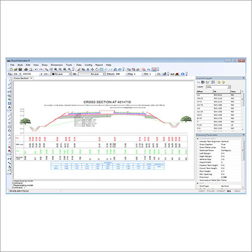
- Plan, Profile, Cross-Sections, Reports and 3D models
- Official tutorials, documentation, and online classes
- Alignment Design, Digital Terrain Modeling, Earthwork Calculations
- Perpetual & Subscription available
- Supports DWG, DXF, and other industry formats
- Offline & Online
- Bentley Systems
- Minimum 4 GB RAM, 2.0 GHz processor, 2 GB free disk space
- Network license management available
- Regular software updates and online resources
MX Roads Software Trade Information
- 1 Number Per Week
- 1 Week
- All India
Product Description
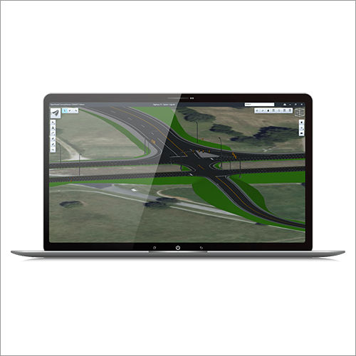
MX Roads Software is offered by us that is a string-based modeling tool that helps in creating the rapid and accurate design of all types of roads. In addition, it is useful for engineers, designers, and surveyors to draw rapid and accurate designs of all kinds of roads. It comes with a design-time visualization that is useful for having a look at the design on the fly.
Advanced Road Design Solutions
MX Roads Software empowers engineers and designers with precise road infrastructure design, offering an extensive suite of integrated tools including digital terrain modeling, alignment design, and earthwork calculations. Its compatibility with widely used file formats like DWG and DXF ensures seamless project workflows and collaboration across teams.
Flexible Licensing and Multi-User Support
Choose between perpetual and subscription licensing to best fit your project or organizational needs. MX Roads supports both offline and online installation and offers network license management, making it easy to deploy for teams of any size. Multi-user options accommodate dynamic project environments and facilitate efficient teamwork.
Comprehensive Support and Learning Resources
Stay up-to-date with regular software updates and benefit from official technical support services. MX Roads offers extensive learning opportunities, including official tutorials, online documentation, and instructor-led classes, guaranteeing that users in India and beyond can maximize productivity and software proficiency.
FAQ's of MX Roads Software:
Q: How do I install MX Roads Software, and what are the system requirements?
A: MX Roads Software can be installed both offline and online. It requires a Windows-based system (Windows 7, 8, or 10) with at least a 2.0 GHz processor, 4GB RAM, and 2GB of free disk space. Detailed installation instructions are available in the official documentation and training materials.Q: What file formats can I import and export with MX Roads?
A: MX Roads supports importing and exporting standard industry formats, including DWG and DXF, allowing effortless integration with other CAD and engineering software used in road and civil projects.Q: When are software updates and support provided for MX Roads users?
A: Regular software updates are available for licensed users, ensuring access to the latest features and enhancements. Users also receive ongoing online resources and official technical support for troubleshooting and maximizing software performance.Q: Where can I access training and learning resources for MX Roads?
A: Official tutorials, comprehensive documentation, and online classes are provided to all users. These resources are accessible through Bentley Systems' online portals and authorized dealers, service providers, and suppliers in India.Q: What is the process for managing licenses and network support in MX Roads?
A: The software offers both perpetual and subscription licenses. With network license management, organizations can efficiently allocate and monitor multiple user access across teams, streamlining project collaboration and license utilization.Q: How does MX Roads handle security and user authentication?
A: As licensed software, MX Roads incorporates user authentication and robust security features to protect project data and restrict access to authorized users only.Q: What are the key benefits of using MX Roads for road infrastructure projects?
A: MX Roads simplifies the design, modeling, and analysis of road projects by providing advanced tools like digital terrain modeling and earthwork calculations. Its user-friendly interface and comprehensive reporting outputs enhance productivity, accuracy, and collaboration among project stakeholders.Tell us about your requirement

Price:
Quantity
Select Unit
- 50
- 100
- 200
- 250
- 500
- 1000+
Additional detail
Mobile number
Email

Other Products in 'Civil Engineering Software' category
Address
GST : 24ALKPS7170A1Z5
- 504, Supath, Opp. Rasranjan, Nr. Vijay Cross Road, Navrangpura, Ahmedabad - 380009, Gujarat, India
- Phone :08045815970
- Send Inquiry
 |
MAHAVIR TRADERS
All Rights Reserved.(Terms of Use) Developed and Managed by Infocom Network Private Limited. |
